We use cookies on this site to enhance your user experience
By clicking the Accept button, you agree to us doing so. More info on our cookie policy
We use cookies on this site to enhance your user experience
By clicking the Accept button, you agree to us doing so. More info on our cookie policy
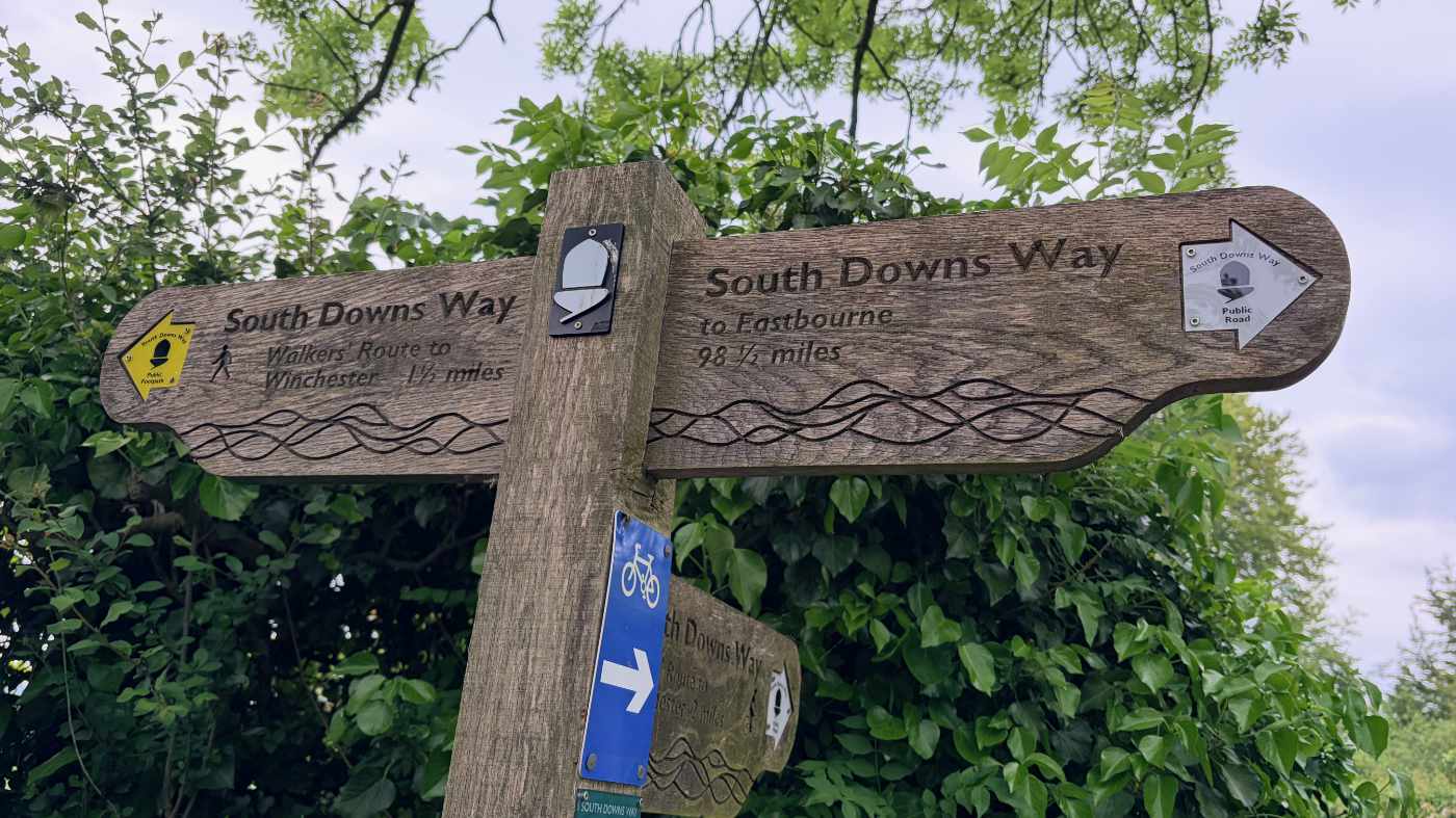
Winchester to Amberley
Published: May 8, 2026 by
Every year a small group of us like to plan a long weekend getaway. In previous years we have visited the Peak District, walked a part of the Cotswold Way and even walked the Ridgeway (that time over a full week). This year we decided we wanted to try doing a bit of thru-hiking, but we weren’t quite ready to carry a tent and all the camping gear too, so thought we would arrange places to stay along the way.
We discussed several different potential routes, including Hadrian’s Wall walk and walking the rest of the Cotswold Way, but something about the South Downs way stood out so we decided to settle on that. The transport links seemed good and it looked like there were more towns and villages along the route that the Ridgeway, making it easier to find places to eat and stay.
For me, there is something special about the UK’s National Trails. Following along the same path, but seeing the scenery change along the route each day. It’s a very different feeling than walking a circular route where you know what to expect when you start heading back to the start. The national trails are also marked by the acorn symbol on the signposts, giving you confidence you are heading in the right direction and a constant companion across the whole route.
The total route of the South Downs way is 100 miles and the national trails website suggests taking 9 days to complete it. As we only had a long weekend of four days, we decided to do just under half, averaging around 12 miles per day.
The route starts at Winchester (when heading west to east) and it turns out there is a direct train to Winchester from Oxford. This would allow us to get dropped off and not worry about doing a car shuffle each day like we did when we walked the ridgeway (driving both cars to the end, dropping one off and driving back to the beginning, then doing the same the other way round). We could then follow the South Downs way to Amberley and catch the train back to Oxford, via London, when we were finished.
Next we needed to work out where to stop each day, ensuring there was somewhere to stay, but also somewhere to get supplies too. I ended up purchasing the Trailblazer guide to the South Downs way, which has some really helpful itineraries based on pace. In the end we decided to do a slightly faster pace than the relaxed pace and a bit slower than the medium pace, working out at around 12 miles per day.
In terms of accommodation, we decided to book three Airbnbs for the Friday, Saturday and Sunday nights, before catching the train home on the Monday.
The itinerary below is the main part of the walk, but you always need to add the bit extra from the South Downs Way to your accommodation and back.
The first day we plan to catch the train from Oxford to Winchester and then walk to Exton - 13.5 miles
The second day is from Exton to Buriton - 13.5 miles
Day three Buriton to Cocking - 11.5 miles
Day four Cocking to Amberley - 12 miles
Like I said previously, this is the first attempt at a thru-hike without having cars to shuffle us back to the campsites along the way. Although we didn’t need to carry camping gear, we would still have to carry everything we would need along the way. Here is a list of what I packed in my bag.
In terms of backpacks, I decided upon a 40 litre EuroHike backpack, which was a great price in Go Outdoors. I have used it for a few day hikes around the local area and it seems quite comfortable. I guess that I will find out for sure how well it works after our long weekend trip.
So we had our accommodation, route and kit sorted, now we just had to turn up and walk the route.
I plan on writing some more posts summarising each day’s route, along with some photos.
This post was written before the walk, but published after. The South Downs Way seemed a lot more up and down than the Ridgeway walk, with more tracks and roads. The views when you climb up high are great, but a lot of the time you are surrounded by trees, which is lovely, but you can’t always enjoy the view.
The path is full of sharp pointy flints and was very hard on the feet. This was the thing that caught me off guard. I did a lot of practice walks before we went, but my feet weren’t quite ready for the surface.
Overall, the walk was very memorable and I enjoyed escaping to the countryside for a long weekend. Thru-hiking was challenging, buy not having to drive each day was great, despite carrying the kit.
Share
Latest Posts
Every year a small group of us like to plan a long weekend getaway. In previous years we have visited the Peak District, walked a part of the Cotswold Way and even walked the Ridgeway (that time over a full week). This year we decided we wanted to try doing a bit of thru-hiking, but we weren’t quite ready to carry a tent and all the camping gear too, so thought we would arrange places to stay along the way.

I was looking online for ways of having some kind of route displayed on my Apple Watch as I was walking. The built in workouts app allows you to track a lot of information, such as distance, elevation, heart rate, etc. but it doesn’t show you a map of where you have been, are, or are heading to. I noticed that the OS Maps app has an Apple Watch app, so I thought I would give that a go and see what it does.
We were looking at the National trails website and saw the Cotswold Way wasn’t too far away from Brackley. We decided to walk a section but wanted a way of parking at the end of the section and some way of getting to the start. After looking at our map, we discovered the Gloucestershire Warwickshire Steam Railway (GWSR).